 aka, el Cañuelo- A National Forest Service, Historic Site
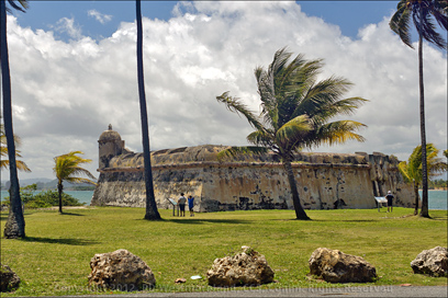
I’ve had my eye on this location since before I made my 1st trip to Puerto Rico. Why? Because I suspected it would have a great view across the bay of El Morro and Old San Juan.. I was not disappointed!
This has to be one of the best, ‘must see’ spots on the North side of the island.
There is a fee per vehicle to enter the park… cars are $3 and our SUV cost $4. Cars or trucks with trailers are more still. That said, there was probably a hundred or more folks, making a day of it! 
New Photo Gear.. Woo Hoo!
This was my first trip out with my new camera,
a Sony Alpha NEX-7, which I’m still getting used to.
For the photographers out there, it sports a 24.3 MP imager, an all electronic eye level viewfinder and weighs a whopping 12 oz. (with battery and card). Physically, it’s on a par with my old Olympus OM-4, a small 35mm SLR.
The big draw for me was the fact that via an adapter, I can mount almost every 35mm lens ever made…10’s of 1,000’s of them. Amazon lists at least 18 different NEX-7 Lens Adapters, most are reasonably priced.
It takes SDHC or SDXC cards and Sony’s Memory stick Pro. 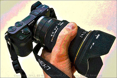
The crisp, HiRez electronic eye level viewfinder makes manual focus a cinch.
Especially in low light conditions.
This is the first digital camera to incorporate an EVF good enough for live manual focus.
On the down side, the APS/C image sensor (as in most digital SLRs) is smaller than a 35mm frame so you have to multiply the focal length by a factor of 1.5X to get it’s effective equivalent.
On the up side, it means you’re using the ‘sweet-spot’ from the center of the lens. Less issues with resolution or light fall-off in the corners. That turns a 50mm ‘normal lens’ into a 75mm short portrait telephoto or a 70 to 210mm zoom becomes a 105 to 315mm telephoto.
That’s fine for long lenses, but not so good for wide-angles.
Fortunately, all of my AF Alpha lenses work via a Sony NEX adapter , though I do have to focus them manually… been doin’ that for years.
The NEX-7 is still in short supply because of high demand and the flooding in Thailand several months ago. I got mine from B&H Photo without lens.
It’s also capable of producing very high quality video, if rigged for it.
Worth Noting- I scored a JTec aluminum, CNC machined, quick-release ‘L’ bracket for the NEX-7 since I shoot primarily from a monopod or tripod.
It makes switching from horizontal to vertical, very easy.
A good practice since the camera does not incorporate any kind of ‘vibration reduction’ mechanism. The bracket only adds a couple of ounces to the whole rig.
Back to the story…
Research… Added Value
One of the things I love about PR is the old Spanish ruins you find everywhere you go. Isla de Cabras is no exception. Besides Wikipedia, I had studied Google satellite images of the area in detail so I had an idea of what to look for.
What’s more, I recently stumbled onto a huge ‘treasure trove’ of Historical American Building Survey material located on a National Park Service server. The files were indexed by state, but without much in the way of details… so I downloaded gigs and gigs of images, maps and drawings. I now have a giant database of historic material to sort through. Most of the field work was conducted in 1977 and ’78.
More about all of that, as time goes by.
Many of these historic sites are under the protection of the U.S. National Park Service or the Conservation Trust of Puerto Rico.
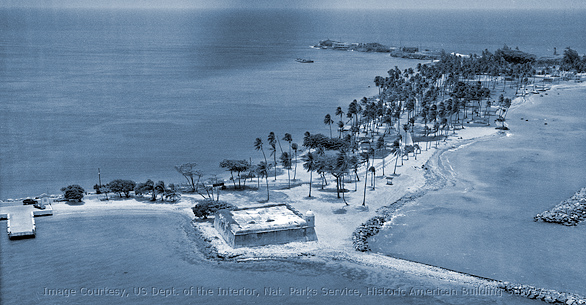
I have included a few items from the collection, relating to this post. The aerial shot shows the condition of the island from before the concessions were added, but after the U.S. Government landfill project. It was taken by Jack E. Boucher in either 1960 or 1967.. probably 1960, 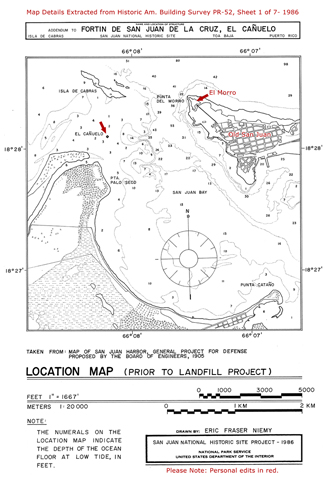 but not sure about the dates.
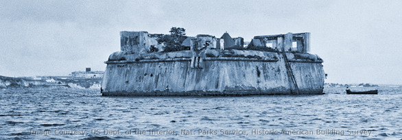
The tight shot shows some of the ruins left from the 2nd story, before the US brought in fill. No photographer credit is available. It was most likely shot in the late 1920’s.
At low tide, the waterline hits right at the base. The map details date to 1926.
Larger images of each, may be seen by clicking on them.
As U.S. Government images, they are not copyright protected, but credit should be given whenever possible.
Photos are cleaned up and cropped in Adobe Photoshop before I use them. I almost always tone the black and white shots too.
On the Ground
Isla de Cabras is located at the end of Highway 870, which is off of Highway 165 as mentioned in my previous post about Cataño. We actually missed this turn on our first run down Hwy 165 so I had to come back.
We are sooo glad we did.
After paying our $4 bucks and crossing the short causeway, we stopped at el Cañuelo for a series of shots. I also walked out the breakwater barrier to score a shot of El Morro and Old San Juan.
It was spectacular!
I captured the entire view in one wide image. No special tricks needed.
If you click on the wide shot, it will launch a 1,758 x 540 pixel image (reduced and cropped from a 6,000 x 4,000 image) of the entire view. Shot with an old Vivitar 24mm F2.8 lens (36mm equiv., Olympus OM mount) at F8.0 and a Polarizing filter to control haze, plus monopod. Some Chromatic Aberration correction in Photoshop was required too.
 There is no easy way to display a 6,000 pixel wide image.
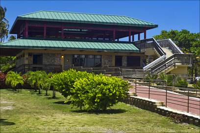 From there, we moved to the middle of the park where there is a large, 2 story concession and restaurant area.
Next to that is an equally large 3 story tall, covered observation deck.
It overlooks the open Atlantic Ocean side.
Sprinkled around this area are several large gazebos with picnic tables. These cost an extra $30 for the day… they were all taken. It was a very busy place.
The park literally has a carnival like atmosphere.
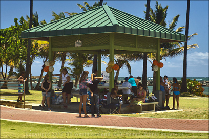 Birthday parties with balloons were most evident. Someone had hired a clown. Even with all the people, there was still plenty of parking. A rare site in crowded Puerto Rico.
There were lots more folks down by the shoreline with lawn chairs and coolers and kids playing in the surf. There’s a shooting range here, but it’s closed to the public. You could hear the discharge of guns the whole time we were there. It didn’t bother me. I wish I could go pop off a few rounds. I miss that about Alaska.. being able to go out and target practice when ever I wanted.
 Continuing on, there is a 2nd parking lot dedicated to folks with boat trailers and a small boat launch off the parking lot. It was a busy place. Personal water craft are very popular.
All the Way to the End
The road turns to dirt at this point.
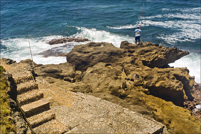
Die-hard fisherman were working the churning surf. Short lengths of 2 inch plastic pipe were planted all over the rocky cliffs with fishing rods sticking out of some. It was a family affair for many of them.
In this high area are the ruins of a couple of red brick buildings.
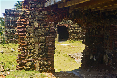 I have to come back and shoot these again.
I’ve seen a lot of ruins at this point and these are some of the best, most well maintained.
It was the highlight of the trip, for me.
There’s also a bar at the very end of the road, but I did not go in.. I simply ran out of time. You can just barely make out the bar, in the old aerial shot… as well as the two dark buildings that make up the ruins.
Yes, There is Some History Here
The first El Cañuelo was constructed of wood in 1610. It played a crucial roll in a battle with the Dutch in 1625 when it was literally destroyed.
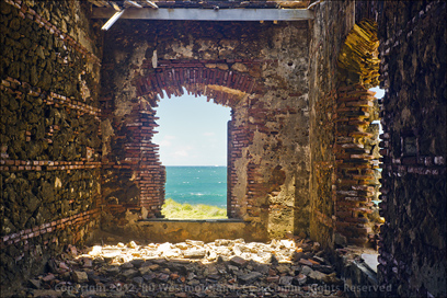 It was reconstructed of sandstone and brick in the 1670’s. During this time, it sat in the bay, off shore in about 1 to 3 feet of water.
It measures about 80 by 80 feet. It had it’s own fresh water cistern and powder house (black powder vault). Several images show the remains of a 2nd story, but that’s all gone now. Isla de Cabras (Goat Island) served as a leper colony from the mid-1870’s until 1926 when a new asylum was built in Trujillo Alto.
I suspect the red brick ruins are from this period.
 The high side of ‘Goat Island’ was used by the US military to install several heavy gun in-placements prior to World War 2. The only thing left showing is the large rusting circular rails the guns rotated on.
It was a short lived installation known as Fort Amezquita.
The Gun Range sits on part of the old fort and you can still see some of the concrete structure, embedded in the hill behind the range.
It’s during this period that the shallows between Isla De Cabras and El Cañuelo were filled in, almost doubling the size of the island.
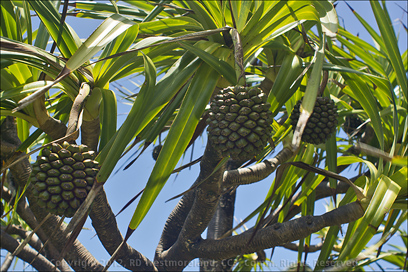
A question for anyone who knows- Can you help me identify the plant in this last shot? The seed pods were starting to shed their seeds. I have never seen anything like it before. Is it in the Palm family?
‘Goat Island’ has something for everyone… it’s no wonder it’s such a popular place. We loved it and will be back.

As usual, larger images from this Post can be seen over on the Scurvy Dog’s
Facebook page.
Historic images courtesy, US Dept. of the Interior, National Parks Service, Historic American Building Survey
Next up: Return to the British Battle for San Juan of 1797
Leave a Reply