 In our continuing effort to eventually visit all of the towns of Puerto Rico, we took a run to the northwest part of the island.
It is about as far from where we live in Coamo as you can get.
In one marathon photo shoot, we covered the highlights of Isabela, Quebradillas, Camuy and Hatillo. Each town will be featured in a separate post, starting with Isabela. The weather for the day was perfect.. sunny with broken clouds.
 My feet were killing me by the time we finished!
Since we were coming from the south side of PR, we took Tollway 52 to Ponce, then Highway 2 past Mayaguez on the west shore, continuing on past Aguadilla.
The ‘retired’ Ramey Air Force Base at the very far northwest corner of PR now provides commercial passenger service as the Rafael Hernández Airport. Though most people don’t know it, Puerto Rico has 3 commercial airports. The one in San Juan is the busiest and most popular, followed by the airport in Ponce. I’ve flown into Ponce’s Mercedita Airport from the mainland, but it was a nighttime trip. 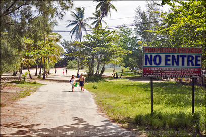 If you plan to stay somewhere other than San Juan, you might want to book your flight into one of these alternatives.
There are also several local airports serviced by San Juan’s International Airport.
We got off Highway 2 at the Highway 110 intersection because we wanted to check out the beaches before heading into Isabela. Highway 110 runs around the east end of the airport where we got off onto Highway 4466. Highway 4466 ends at the junction of Highway 466… If you stay to the shoreside of 466, it will zig and zag all the way into Isabela. 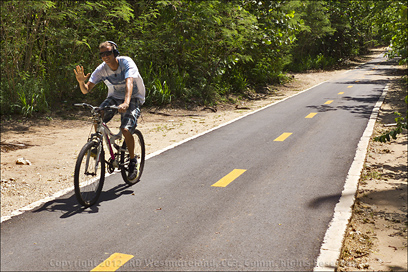 It’s hard to call these local roads ‘highways’ as they are little more than the equivalent to paved streets. None the less, they were in very good condition.
The Beaches of Isabela
There is a lot of housing and hotel developments along 4466 so access to the beach is pretty limited until you hit Highway466. From Google Maps, you can see several of the local beaches. I should also note that we did not hit ALL the beaches open to the public since you would need a Jeep or dune buggy to reach them. No 4-Track signs were posted in several locations.
 Security is always a concern. If it don’t feel right, don’t do it.
If there is already a crowd present, then it’s probably OK. But if no one is around, you need to stay vigilant. As you would, anywhere.
Beach #1- Playa Jobo was our first stop. There was limited parking by the side of the road and a huge ‘Private Property, No Entry’ sign posted. There was a local dude at the gate, but I suspect he was there to collect parking fees from those that went through the chain gate. It was still early… about 11AM so there were only a few sun bathers out.  He let me in so I proceeded to score a few shots. The beach was very nice… several bars and restaurants were strewn along the high side of the shore. The crescent shaped beach forms a small point made of very sharp rock. One of my shots was taken from there. Across the dunes to the east of this area is more open beach. I saw no public facilities, though it was obvious this was a popular place.
I did not get shots of Playa Montones as it is mostly obstructed by housing with little public access.
Beach #2- The next area we checked out was Paseo Lineal Zona Costera. This very nicely constructed and maintained bike path runs along much of Highway 466. At one point, it crosses the road and takes off along the high side of the shore. There was public restrooms, but they were boarded up. This facility was opposite a large Coconut Palm plantation.  I climbed the hill above and took a shot of the shoreline to the west. I believe this area to be Playa Las Golondrinas, but I could be wrong.
Beach #3- The sand dunes and beach around La Pocita de Isabela is extensive. There are several places from the road to access the area with at least 2 different parking lots. Most of it is in the open so you would need an umbrella to escape the direct sun. This was my favorite of the 4 we looked at and covers about a mile of open shoreline. Plenty of room for everyone. As with the previous 2, I saw no public facilities.
I did spot a spent 12 gauge shotgun shell on the beach…
A common sight when I lived in Alaska, but not here. Bird hunting is permitted in some parts of the island.
 I also noted the presence of a US Coast Guard Helicopter and a US Border Patrol SUV in the area when we were there. Have no idea what that was about.
From there, we went on into the Plaza of Isabela.
The Plaza of Isabela-
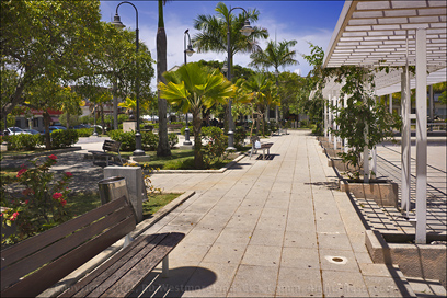
The Plaza of Isabela is a mix of bright open space with some shade trees around the outer edges. A classic Catholic church sets just off the plaza as does the Mayor’s Office, the ‘Alcaldia’.
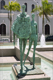
Near the middle of the open space is a contemporary statue of a young couple, standing on a pedestal within a small clear pool of water. This feature is connected by a small water channel to a larger pool with a row of fountains.
 Surprise of surprises… it was turned on!
I’ve been to a bunch of plazas at this point and some have fountains. Most are never turned on.
This was impressive and a joy to see!
As hinted at in the headline, Isabela and the surrounding area is known for it’s flowers. This was the first plaza I’ve been to that incorporated a long open, overhead trellis into the plan. It was a truly unique layout. There was also a small dedicated area for staging events.
 Historically speaking, the area around Isabela (the region known as Guajataca) was home to one of the most famous Taino Indian chiefs… Mabodamaca. He ruled this part of Boriken (Puerto Rico) during the 18th century, before the Spanish showed up in large numbers.
The original Spanish settlement was known as San Antonio de la Tuna (Tuna is Spanish for cactus), but was later relocated closer to the coast and renamed Isabela for the Queen of Spain.
 The new town was founded in 1819.
The first church was built in 1824, but was badly damaged from the Earthquake of 1918 and was subsequently rebuilt. The current Alcadia was built in 1922. The population is estimated at about 45,ooo. I’m glossing over much of this… more details can be had from Wikipedia.
Isabela had a very nice, very clean plaza.
 Back on the Road-
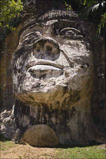
We took Highway 113 out to Highway 2. At that intersection is a very popular, very large sculpture. An ‘Homage to Taino Indians‘ is locally known as ‘La Cara del Indio’, dedicated to ‘Cacique Mabodamaca’. 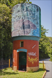 It’s easy to spot from Highway 2.
Heading east down Highway 2 a short distance is the turn off to the Guajataca Tunnel. The exit is to the right and then turns left, taking you under the highway. The road will take you past a brightly painted concrete water tower used in the old days to service steam engines. The road empties out into a large parking lot opposite a stand of Coconut palms. These palms open to a beautiful beach with a view of the Tunnel to the west.
It’s one of the few beaches with a natural sun break. They need to do this to more of the public beaches in PR.
 The Guajataca Tunnel is part of the remains of of the National Railway System that connected Isabela to Quebradillas. It was declared an historical monument by the Government of PR in 2000.
As can be seen in the photos, a concrete floor was laid, but some of the bare rock walls and ceiling are still evident.
Most of the interior walls are covered with scribbled graffiti.
Just outside the tunnel on the beach side, is an abandoned, boarded up bar and restaurant. It’s quite the eyesore and should be remodeled or torn down. It looks real bad.  Especially when you compare it to the rest of the area. I’m sure it was a ‘hot spot’ back in it’s day, but it’s day has come and gone. Time to do something else with it.
The tunnel curves around the hill and opens to a short manmade opening through the next hill. The rock in this area is very porous so there are lots of little caves and natural cutouts. Past this is a long path with a great view of the ocean.
The path continues on, but my feet hurt so I turned around here.
This is a wonderful beach with great views of the ocean. But they need to do something with the old bar and restaurant… it ruins the whole place.  We took the road back to Highway 2 and headed for Quebradillas.
All in all, I really like this part of the island.
This is what I think of when I think of Puerto Rico. It seems so far removed from the hustle and bustle of the mainland. We plan to eventually come back and check out the caves in the area as well as the abandoned sugar mills. We had too much to cover in one day to stop and shoot any of that.
There was only room to show about half of the shots I got. Many more and larger ones can be seen over on me Scurvy FaceBook page. Check it out!
Next stop- Quebradillas.


giovanna ramos says
nice my birth place luv it
sandra santiago says
Love it
Evelyn says
Nicely done, beautiful pics, thanks for info. (S.Dog- ARRG!)